
ABOUT QIBLA DIRECTION
-
Question: What is correct Qibla direction from North America, North-East or South-East? Some people show on the flat map that Qibla should be South-East.

Answer: Earth is NOT flat as some people still believe. No one can give them knowledge except Allah. But those who ponder on this have clearly seen that the earth is approximately round. Earth's shadow on moon is visible at Moon Eclipse, and it is always round. Other proofs of roundness are observations; when a sailing-away ship is seen on the horizon for a distance it vanishes slowly going below horizon, etc.
For Qibla direction, when people debate the direction for North America as being North-East or South-East, the problem is lack of understanding that the earth is not flat so you should not look at flat map. The round earth gives a different perspective. If you look at the globe then may be you will see that the direction from Alaska to Makkah is due North, although Makkah is South of Alaska. If there were a minaret over Ka'bah that was so high that it reaches the sky, then you could see it from Nova Scotia and it would be in North-East direction. In fact the sun comes approximately overhead above Ka'bah on two dates every year. That is like a minaret over ka'bah. See the circular map of the world and explanation below it on Qibla direction page.
The correct direction of Qibla, from North America in general is North-East, except on North-west corner of USA and Alaska where Qibla is almost North. -
Question: Some people talk about shortest distance concept about Qibla. What do you have to say about that?
Answer: If you go to Masjid-al-Haram in Makkah, you will see that people make circles around Ka'bah when they pray. These circles continue to grow as you go farther and farther from Ka'bah. Every person on these circles is facing toward the shortest distance from Ka'bah. Imagine this circle growing and growing on the surface of the globe. Every person on these circles is actually located on another circle called Great Circle defined by the largest circle you get if you cut the globe by a knife in two equal halves, such that the knife cuts through the location of that person and Makkah. The plane of this Great Circle makes an angle from True North. This is the angle you should turn to face Ka'bah. Renouned Muslim astronomers like al-Biruni, al-Battani, and others in the last 1000 years have described this concept.
-
Question: If we keep going west from Makkah we pass over Africa then the Atlantic ocean then we arrive at Florida. Doesn't it make sense in this case for Qibla to be EAST. (Dec 5,1997)
Answer: No, my dear brother. If you keep on going exactly west, you will also eventually come to India. Would you still face East? No because from India, Muslims face West. So, Qibla can not be deduced from how you travel. The best way to understand is, that we know that two times a year, the sun comes exactly over Ka'bah at Makkah noon time on May 28, and July 16. If you can see the sun at those two dates at Makkah noon time converted to your local time, you will actually be seeing a very high minaret, if there were any, over Ka'bah. Wouldn't you face towards it? This observation has been made by Muslims all over the world and that is the correct direction of Qibla. Observation like this from Nova Scotia has been made and confirmed that Qibla from there is North-East. May Allah help you understand and search for the truth, without any bias.
-
Question: What is the importance of Magnetic North Pole and True North Pole. Which one is marked as the North Pole on the globe that we have at schools. (Jan 31,1998)
Answer: True North Pole is marked on the Globe as a top hinge of the stand. Magnetic North is the direction where a magnetic needle would point if it is pivoted freely, because it aligns with magnetic field inside the earth. This North pole of magnetic field differs from True North pole by several degrees at some locations (e.g. in California it differs by 14 to 21 degrees, and in Alaska it differs by 16° to 34°)
-
Question: What is the direction of a line from Vancouver Canada to Makkah that goes straight through the earth (not on the surface) using the North, South, East and West orientation, and why? (Jan 31,1998)
Answer: When you want to face Ka'bah, you are not facing a line, but you are facing a vertical plane that contains a straight line inside the earth to Ka'bah. So, for a direction, you never face a line, you face a plane. Now the plane that would contain the line that you defined, inside the earth, is the plane that has a direction of 16:41 East from True North (North Pole of the Globe) for Vancouver to Mecca. However, if you measure the angle from magnetic compass, it should be 3:09 East from Magnetic North.
-
Question: Most of the mosques in Montreal pray at 320 grad from North. Since all Muslims here pray at 320 grad I also pray in the same direction. I have a booklet bought from Medinah in 1992 which says 270 grad from North and which seems logical geographically if seen from the map. What do you know about this matter. Please guide me in this regard. (Aug 26, 1998)
Answer: Conversion of grad to degrees is as follows:
Grad=400-degrees/0.9 or Degrees=0.9x(400-Grad)
Actually, Qibla for Montreal from Magnetic North is about 74.6° East, which is equal to (400-74.6/0.9) 317 grad, which is close to 320 grad you mentioned. That puts Qibla in North-East direction.
270 grad is equal to (0.9x(400-270)) 117 degrees from Magnetic North, which puts Qibla in South-East. Looking at a flat map one gets the impression that it should be South-East, but the earth is not flat, so a flat map gives a distorted picture for the direction. You can resolve this fallacy by looking on a globe, and see where the Qibla should be from Alaska. Put one finger at Alaska, and another finger of the other hand on Makkah, You will see that Qibla will be in the direction of North Pole, meaning Qibla from Alaska is due North. While on the flat map, it would appear to be South-East. Also consider eastern edges of Russia; if you look on a flat map, Qibla from there would appear to be South-West, but on the globe you can see it again that Makkah would be in the direction of North Pole, meaning Qibla from Eastern edges of Russia is approximately due North. Both Alaska and Eastern edges of Russia are very close to each other, and the direction of Qibla has to be approximately same, but the flat map gives two opposite directions. You can read more on this subject on my Qibla Page: -
Question: I live in St. Louis, Missouri. What time can I observe the sun on those two dates to convince myself about the controversy of South-East and North-East? (April 9, 1999)
Answer: The time difference for Missouri from Makkah time is -9 hours. So, the time for you would be 3:18 on May 28th or 3:27 on July 16th. At these times the sun has not yet risen in Missouri. So you cannot see the sun at those times. However, when the sun rises about two and a half hours later, at 5:40 on May 28, or at 5:49 on July 16, then you can see the rising sun and estimate where was the sun about two and a half hours ago (certainly on the left of the rising sun). That direction would be North-East and not South-East.
-
Question: I think, it does not matter whether the earth is flat or round, the direction for Qibla as I see from North America is South-East. I bought a globe and tried to look from Alaska, I see that Makkah is still down somewhere, therfore, it should be South-East, not North-East.
Answer: The proponent of South-East as the direction of Qibla from North America are giving only the argument that North American continent is North of Makkah and West of Makkah, therefore, Qibla should be opposite to that meaning South-East. This is all due to flat map, latitude & longitude lines, and preconceived idea that Makkah is somewhere down from Northern latitudes.
Makkah is at a longitude little less than 40° East. Now, ask yourself about Qibla from any place in Alaska (approximately 140 West longitude or more), and the Qibla from Yukon Territory of Canada (less than 139° West longitude). By the flat map theory, the answer for Alaska would be South-West and the answer for Yukon would be South-East. Does that make sense, for two places adjacent to each other. If one is impartial from the preconceived notion mentioned above, one must think it rationally. It doesn't make any sense to me!
The idea of a minaret over Ka'bah is simple, that the sun comes over Makkah on May 28, and July 16 every year around local civil noon time (not exactly at 12:00 noon). Noon time is defined as the time when the sun is at its highest point in its journey from sunrise to sunset. The sun shining at exactly over Makkah makes an imaginary minaret over Ka'bah. Looking at that sun from anywhere on the globe is the correct direction of Qibla. Only two things are needed to verify this.
1. Either go to Makkah on those two dates or ask someone in Makkah on those two dates to verify that the sun comes over Ka'bah at 12:18pm on May 28, and at 12:27pm on July 16.
2. Go to Nova Scotia or ask someone there on those two dates to see the sun at those times, and check the direction.
If you do those two things, there would be no controversy.
-
Question: What is Qibla from San Francisco? I was told to rely on the sunset to find Qibla. But I think that is only effective in Pakistan.(July 5, 2001)
Answer: The sunset direction in Pakistan is also not right for Qibla. For example in Karachi, the sunset on Jun 21 is 28° off from the Qibla direction, and sunset on Dec 21 is 24° off from Qibla direction.
From San Francisco, Qibla is about 19° East from True North. Remember, you cannot get true North by compass, as it points to Magnetic North. Using compass you must know the variation between True North and Magnetic North for your area. In San Francisco, that variation in 2001 is about 15.5° East from North. So, you will use (19-15.5)=3.5° East from Magnetic North.
But, a Table for next 60 days can be provided to you, that will help you locate Qibla accurately from the shadow of the sun. Just look at the shadow of anything on the given time of a given date, and that direction would be your Qibla from San Francisco.
-
Question: If accurate angle for Qibla is known, why is it not advisable to use it?
Answer: Accurate angle (no matter how accurate) does not help, because the angle is calculated from True North and instruments that measure the angle are based on Magnetic North. The variation between True North and Magnetic North is different at different locations and is continuously changing although very slightly.
For orientation of Masjid the most practial method is from the position of the sun. For any location, such times to observe the sun can be calculated at which time the shadow of any vertical object would give Qibla direction, or facing the sun would give Qibla, or the time when Qibla is 90 degrees from the sun or the shadow.
-
Question: If I can see the sunrise, would that be East? Turning 90 degrees left from that direction should be True North; am I right?
Answer: No, you are not right. Sun does not rise from East except on March 21 and September 21. It rises from slightly North of East between March 22 and September 20. Then after September 21, it rises slightly from South of East between September 22 and March 20. You cannot determine the True East or True North from the sun except on March 21 and September 21.
- Question: How a person would find Qibla direction from another planet or from space?
Answer: From another planet or in space, one would face a line in space that goes exactly above Ka'bah (This line is the one that connects Ka'bah to Bait-ul-Ma'moor in the heavens). By 3-D trigonometry, it can be calculated from any point in space, how to face such a line. Even on earth we face the same line, not the ka'bah itself.
- Question: How is it possible that you can see the sun rising from North-East direction (058degrees East of North) at Nova Scotia, Canada and Maine , USA on the dates May 28 and July 16 when the sun is right above Makkah, Saudi Arabia at noon time. The sun never goes North of the Tropic of Cancer which is 23.5 degrees North of Equator. The sun comes over the Tropic of Cancer on June 21 and then starts moving southward towards the Equator.
Answer: Yes, what you are saying about the sun not going above or below the latitude of 23.5 degrees from equator is correct. However, which direction the sun would be seen from a location on the globe has nothing to do with 23.5 degrees.
The earth revolves on its axis in 24 hours. In those 24 hours, the sun appears in all directions (North, South, East, West, and all other possible directions). If at any moment during 24 hours the sun appears in North East direction, then what is the surprise that the sun appears in North-East direction.
Moreover, if you know some people in Nova Scotia (Canada) or Maine (USA), you can ask them to observe the sun, and check the direction.
- Question: What is the latitude and longitude for Makkah? Can I use those coordinates to find Qibla or more accurate coordinates are available for Ka'bah?
Answer: Makkah coordinates are 21:26N Latitude and 39:49E Longitude (The Times Atlas of the World, 8th Edition). More exact coordinates for Ka'bah are 21:25:24N Latitude and 39:49:24E Longitude (Army Corps of Engineers Pakistan).
- Question: Let’s says that the circle around the Qibla kept growing very large. Let’s say that it kept growing so large that somehow it covered North America. Would those in North America (Eastern part) still be facing North-east?
Answer: Yes, the growing circle would cover North America (Eastern part), and it still be facing North-east.
- Question: Does the Quran or Hadith offer any guidance for usng shortest distance to Makkah in determining the Qibla direction?
Answer: Qur'an says, "wa haisu ma kuntum fawallu wujuhakum shatrah" [2: 144] or "wa min haisu kharajta fawalli wajhaka shatral-masjidil-haraam" [2: 149]
In this guidance is built a commandment for facing towards Ka'bah which is only possible by looking in the direction of shortest distance, which is only the direction of vision.- Question: Muslims who came to North America in the parts of the last century built their mosques facing South-east. Were they doing this on the false premise that the world is flat?
Answer: Those who built masjid in North America facing South-East have been under the premise of their own understanding, surely thinking they were right. (No blame should go to them). If we know better now, we should build masjid in the correct direction and try to always pray in the correct direction.
- Question: Scientists at NASA said December 2004 earthquake in the Indian Ocean affected the shape and rotation of the Earth, and shifted the position of the North Pole about 2.5 centimetres, or one inch, closer to 145 degrees east longitude, roughly in the direction of Guam. Would this "shift" have an impact on Qibla calculations e.g., True North vs Magnetic North? (January 13, 2005)
Answer: This small shift of 1 inch in the calculations of the earth diameter of 8000 miles is not going to make any difference. The continuous small change in magnetic field has more effect than this shift would. However, USGS updates its map for declination (difference between True and Magnetic North) for the whole world every five years or so. That update has to be incorporated in the calculations which we are doing periodically as the time passes.
- Question: Is the Ka'bah really at the centre/heart of the Earth geographically?
Answer: No! Ka'bah is not the center of the earth geographically. Earth is a sphere (more or less), and there can be no center on the surface of a sphere. If one can pick a point on the surface of the sphere to be the center, then every point can be considered as the center.
Those who say Ka'bah is the center, are trying to manipulate the argument on flat map or other irrelevant things. I have seen books written on it with absurd arguments. Some say, it is the center of land masses. This is absurd too. By no mathematical means anyone can correctly prove that hypothesis. Moreover, all land masses of the continents are floating in the oceanic waters, which are floating over the molten core of the Earth, and they all shift over a period of time. With such shifting, the center of land masses also shifts. Whoever came up with the notion, "Ka'bah is the centre of the Earth" is trying to prove un-necessary hypthesis.
- Question: What is Polaris or North Star?
Answer:
POLARIS or NORTH STAR or POLE STAR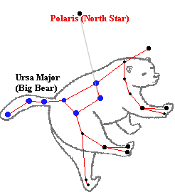 The famous Pole Star (also called Polaris or North Star) lies less than one degree from the Northern Celestial Pole, and so always lies north from an Earth-bound observer's point of view.
Pole Star can be found by locating the Big Dipper (Ursa Major or Big Bear - the stars shown in blue) in the sky. The Big Dipper is a cluster of stars consisting of 7 bright stars, forming a dipper, a small pot with a long handle. Astronomers name it "Ursa Major," Latin for "the big bear." The piture shows how the shape of Big Dipper looks like (7 blue stars on left in the picture), so that you can locate that in the sky. Once you locate the Big Dipper, imagine a line connecting the two stars at the front of the "dipper" (last 2 stars), continue a line from those 2 stars to the side where the dipper is "open" to a distance 5 times that between the 2 stars, and you will arrive at (or very close to) the "POLE STAR" which is a faint star.
Its altitude (the angle it makes with the horizon) is always equal to the latitude of the observer. Since the altitude of the Pole star is always equal to the observer's latitude, if you know your latitude, that's how high from the horizon the pole star will be. So, if you are at Equator, the Pole Star will be zero degrees above horizon.
- Question: How one can find True South with Just an analog Watch
Answer:
1. Take into account the daylight saving time (DST), also called Summer Time by subtracting 1 hour (moving the hour hand counter clockwise 1 hour).
2. Face your analog watch, align it so that the hour hand points in the direction of the sun.
3. Now imagine a line starting from the center of the dial halving the angle between the hour dial and 12 o'clock. This line will point south.Of course, you'll need to take a different approach if you're near the equator or in the south hemisphere.
 Back to Top
Updated April 11, 2019
Back to Top
Updated April 11, 2019
- Question: How a person would find Qibla direction from another planet or from space?